Home can't be more peaceful than when it is first spring cleaned in summer. Books straightened, cds piled, bed shifted - so the dust build-up can be vacumned and for change - skirting boards damped down with a wet cloth. But our home is very close to the outside world. In a northerly you can hear it throbbing. The door grates, towels whip on the line and the pohutukawa hisses.
A rather fragile looking craft has braved the swells of Evans Bay and is making hard work of it. It is wild out there, and the boat is crashing heavily into the gleaming face of the waves. It makes me think of the ocean. What it is like to be out there. My memories are further stirred by reading Bob McKerrows blog. Bob is an adventurer, writer and humanitarian working in Indonesia and currently visiting Banda Aceh on the 5th Anniversary of the Tsunami. On Boxing Day in 2004 the ocean reclaimed Banda Aceh and many of its people, yesterday looking at Bob's blog the ocean was peaceful, just like some days Wellington Harbour can seem like a pond.
We visited Aceh last year and travelled by boats, similar to those in Bob's blog through many of the small islands off Sumatra's west coast. Travelling from Singkil to the Banyak (many) islands we were hit by a squall and our fellow travellers looked anxious, but on another occasion we sat on the prow of a coconut boat alone on the ocean and watched the sun sink into the Indian Ocean.
Reading Bob's blog and looking out at the ocean now Indonesia doesn't seem so far away. Our ocean, despite its different name, is the same ocean that washes up against the many islands, its the same ocean that swallowed Banda Aceh that the flimsy craft is still battling against outside my window. Its an ocean so vast, and yet so small, depending on how we percieve it from one minute to the next.
Last night saw the fruition of a little project I have been helping out with, the Great New Zealand Santa Run. I was the manager of the Wellington Event with the Nationalbig boss being Shaun Collins of Lactic Turkey Events. There is a nice write-up about the event in the Dominion Post and on Stuff here.
Grateful thanks to my Santa marshalls for their sterling work, the only errors on the night being mine, dammit! I will post some photos of the run and marshalls soon as...
Filling in the pieces of missions to do around Wellytown. This one was Titahi Bay to Makara Beach, and a bit of a walk back. Jenny, Mark, Chris, Rachel and I started early at Wellington Station catching the train and bus to Titahi Bay. On the way the going was good and the weather improving to scorching so swimming was de rigeur and sunburn post facto.
Not many necessary swims, just one I think for Mark who likes climbing, but plenty of opportunities for getting wet if you so desired. Highlights included the crazy rock, views of Kapiti/Mana/South islands, Boom Rock, Goats and milkshakes at the end.
Looking south towards Makara, and the crazy rock
Oystercatchers - Mana from Boom Rock and the team.
Photos of the day, credit Jenny Cossey
...and action photo, with close-up of perfect technique
Here's a quick vid from Mick of our trip in the weekend, doubling as a promo for the National Rogaine Champs next April. See us trying stay dry!(and failing)
Well I've got mixed feelings about this mission, you see it was a long time coming and seldom have I failed so bad in completing a mission. The idea was great, a traverse of the Whakatikei river from source to sea. But it wasn't to be, among other things my ankle wasn't going to let it happen. Bodies! One day primo the next day poked. Mortality sucks. On the positive side though it was a great afternoon out with a couple of mates; Mick and Ramash, in a neat little part of our world. Here's to that.
The Whakatikei is a rugged part of the Akatarawa range that drains eventually into the Hutt river. It is targeted eventually to be the next dam site for Wellington water consumers. But at the moment it is just a beautiful mostly prisitine hidden gem on the edge of our capital city.
The headwaters of the Whakatikei is the east tending stream in the middle of this (old) photo.
The first task was to get to Paekak, and in true carbon conscious fashion we took the train. Note to self, "trains run on time". Reunited we headed out through Paekak cutting through some farmland on QE 2 park (or maybe not - see land boundary below Mick) to McKays crossing, and then up through the old Whareroa farm which is being actively developed with walking tracks as part of a green corridor from the sea to the hills.
There were no tracks where we were going however. Straight up the hill following a fenceline watching the ocean and Kapiti island grow bigger behind us.
Wainui is capped by a couple of hundred metres of bush and we soon ploughed into this following a rough, but appreciated route, marked by a local DOC ranger, at 722 metres Wainui peers down at a fault line running along its western foot known more commonly as transmission gully, but in the mist we couldn't see much at all.
For us there was only time for some preventative foot action.
And them it was down into the creek, and what a little beauty it is, slimy rocks quickly give way to bigger grippier bouders or level riverbed to gallop down, and the trees are big, rata, rimu and the other podocarps tower all around when the lower canopy parts from time to time. Or they fall and provide obstacles or features in the gorge.
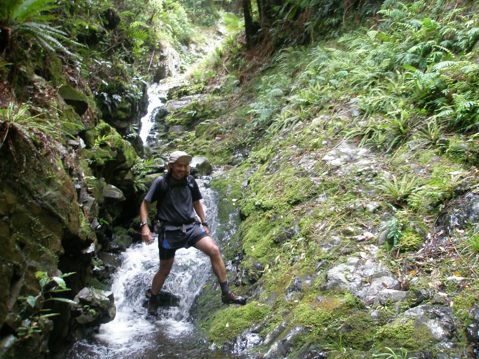
We had the occasional swim or scramble. It wasn't warm out of the sun, but even in the deepest confines of the valley the sun was never far away.
Out eventually, and it was power lines that signalled our return to civilisation, or not. We were at least out of the gorge, but we were still in the middle of nowhere. It made me reflect that in New Zealand some of our best adventures are in "pylon country" where electricity infrastructure required the battering out of roads across hostile terrain. I'm thinking the Borland Road, Dennistoun to Lyall on the Buller, McKenzie pass down south. Pylons can be beautiful with history and nostalgia on their side.
Being in the middle of nowhere we walked around the corner and bumped into "Orange Hut". The mythical heart of trail bike and 4wd drive culture around Wellington. True to its name it is painted Tui colours (as in the beer) and smells of man. Outback man. A concrete silo with bunks its austerity is only just resistant to the the type of graffiti and abuse that huts within reach of petrol powered transportation are subjected to. Mores the pity, it is a good spot.
It was here that we bailed, turning our backs of the further river journey opportuned and heading home with our tails between our legs, following the pylons back to Whareroa and down the hill. A good mission left incomplete for another time.
Time has slipped by me the last couple of months, and the urge to get creative and communicate through this blog has been subsumed by the cravings for the couch and contemplation, and the bike and perspiration. Not to mention a bit of navigation on the side.
First though we went to Tonga. It was a get together of a group of friends from Gisborne and before, and we stayed with the family of our old flatmate Mike, who own a surf resort on the North Shore of Tongatapu.
Us and then the gang of Techno Tonga 2009
It was great to catch up and relax with friends we hadn't seen for a while. There was plenty of cocktails on the beach, reading books, surfing and snorkelling going on, a touch of volleyball and a magnificent table tennis tournament, won by Mike the Tongan Tornado. In the photo below I declare the eventual runner up "tighty whitey" the winner of an earlier round game.
Outside the friends, frivolity and beach Tonga has little to offer a traveller after aesthetic beauty and outdoor recreation with a wannabe ecologist bent. It is a small flat island with far too many people and churches and too little biodiversity. The prominent fruit bats were a gift to the king sometime last century and apparently eat mosquitos, but have also decimated the islands mango supply. Having them flapping around in the daytime seems to me at least a metaphorical exclamation of a collapsed eco-system.
So yeah it was really a beach and beer trip.
I guess since and before then there have been a few strolls and missions around Wellington. Mum and Dad came up to Wellington and I took them over to the fantastic Matiu/Somes Island. The island in the middle of the harbour we look out to from our lounge which is now a nature reserve and home to all kinds of cool creatures like parakeets, giant weta and tuatara.
And before then, I think, there was the rubbish clean-up down at Evans Bay which I organised. There was a great turn out of people who learnt a lot about the micro-trash we are pumping into our oceans every minute. Thanks to all those that made it out, especially those under duress!
Another great little trip we did was the Haurangi Crossing, a mountain bike out in the Wairarapa. The team for this one was us, Jacqui, Ramash and Greg. Starting just south of Martinborough we headed down the main road towards Cape Palliser. It was a pleasant rolling road with a tail wind the highlights of which were the quite fantastic local store after about 10km (long enough for a pie) and the appearance of a snow covered Tappy, a feature in this part of the world, as we descended into the bays of the south coast (Mt Tapuaenuku of the inland Kaikouras is 150 kilometres away across Cook Strait).
From the south coast it turned ugly as we headed uphill into the Haurangi range. Real ugly. Brutal. It was Pennys first mission on her new bikeand she was pretty tough to come through it. To survive. The Haurangis are low, steep hills covered with scrub and the odd patch of remnant forest. It is one of those hunters paradises, where men get to cruise around on quad bikes with guns having fun. After a few hours or more we emerged on the far side with 30km's or so to go to the car along a lovely gravel road. Good times.
Rightio, thats about it apart from a few orienteering events and general cruisings around, hopefully clearing the decks will encourage me to get more creative on the blog again.
My mate Caspar has done a great blog on last Sundays mission, read it here.
Caspar, Ramash and I went looking for bush and creeks. We started by climbing the brutal 4WD track up Climie from Tunnel Gully that we reccied a couple of months ago. This time however we dropped straight off the back of the Hutt Valleys ventoux into Climie Creek. Once we remembered that wet bushbashing was best done with raincoats on it was a blast (its just that it had been a while).
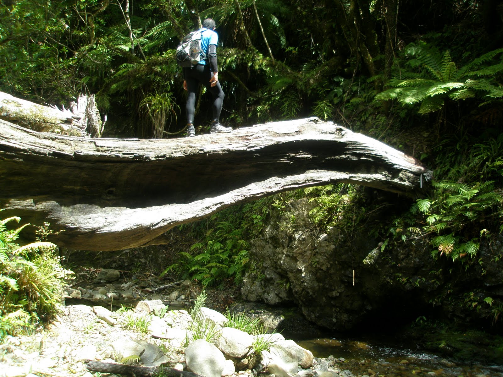
The subsidiary ridge dropped us in the creek pretty quickly but there were no obstacles that weren't easily skirted or scrambled. Ramash comes into his own on rough terrain and Caspar does a good monkey imitation so were made pretty good time with my gimpy ankle holding up.
It was great to meet the Pakuratahi River. Pouring down with a touch of tannin from the centre of the Rimutakas. The forest is powerful here, Rimu's and red beech lord it over the lesser shrubs, and we just pass briefly. The journey down river to the old railway corridor was fun bush travel practice, but little of a serious nature with these water levels.
This could be a wilderness river anywhere in New Zealand, what a spot!
Out onto the incline and it was great times, running and occasioanlly sprinting between interpretation panels. Learning the storys of the people and steam engines that had passed this way before. A real highlight for me was running lightless through the long tunnel, with only the distant shield of light to guide you. After a while it feels like the shape of light is hovering in your vision, moving backwars and forwards, levitating, and it becomes quite a surreal experience until the brush the rough concrete with the back of you swinging hand.
Emerging on the far side to the wasted foothills where forest and eight species of Moa once lived, you wonder of what mistakes we are making now that are the equivalent of these mistakes they made in the past. I was surprised to learn that the fires in this area were often started by sparks from the great steam engines that rumbled up these steep inclines.
Great mission, thanks heaps guys.
A week or so ago on a Saturday night I realised that Sunday was looking good for a walk. My call found Greg Thurlow in a spa with a few drinks under his belt, but he was easy to convince. 7.30.
The pick-up went smoothly, though the parcel was looking a little ragged around the edges. Up over the Rimutakas again and the discussion was inevitably on the weather. The ragged Tararua veteran thought it looked windy. The hopeful Tararua newbie thought it would ease off. We were out of the Holdsworth Road end speedily, jogging to get to the tops as quickly as possible. Runners get to Powell Hut in under 60 minutes in the annual Holdsworth Jumbo mountain run and while we weren't quite on that pace with a bit of gear and food on our backs it was solid.
Greg emerging on the Holdsworth Tops - Totara Flats of the Waiohine beyond.
We zoomed in and out of Powell, the tops were too enticing. Holdsworth summit passed, and the pleasant ridge to Jumbo. After this it was new territory for me. Angle Knob, then dropping down until a bizarre cluster of rocks on the ridge signalled the turn-off to McGregor Bivvy. Its not too far down to McGregor and it is a wicked spot. High on a ridge it is in the ampitheatre of the Tararuas. From the left the main range comes rolling up with the massif (excuse me for using a aountaineers term while bush-walking) of Crawford and the Carkeek and Dorset ridges lapping down off the northern Tararuas. The best perspective though is the southern face (there goes that mountaineers language again) of Girdlestone.
And a few more photos of the vicinity:
Back up onto the ridge from the Biv, and over McGregor proper. One of the 15 or so Tararua peaks to top 1500metres. The most difficult part of our little expedition was to come though, the infamous Broken Axe Pinnacles.
Much to my mother-in-laws delight we chose the sidle route, which was still slippery enough. She was only delighted because she had taken the high route a couple of years ago. Made of sterner stuff those old timers! After this point the travel became easier again, if not a little up and down through the Kings. Mitre was showing off its western flank and the nice little waterfalls of the South Mitre stream and the slowly rising ridge of Girdlestone is very elegant
It wasn't long before Girdlestone, then Brockett and Mitre succumbedthis time to our increasingly weary feet. It was a pleasant time to be up there in the early evening as the wind died away (and the Tararua newb won the weather forecasting debate;-)). The view back along the range shows some nice country covered.
All that remained was a jog down to Mitre Flats hut then a wander back over, into and down the Atiwhakatu. A great day out in the Tararuas!
Gale force nor-westers generally aren't the ideal forecast for the Tararuas but a few weeks ago we headed in regardless. The team was Caspar Harmer, Greg Thurlow and us, and what a couple of companions. Muppets, but in the best of ways. Back seat from the rear vision mirror they reminded me ofStatler and Waldorf ;-)
The trip started auspiciously. We stopped for fuel at the BP heading off to the Hutt. Penny checked oil and water, and I went in to pay. It was only ten minutes down the road we realised we hadn't pumped any gas! In good humour though we then had the Rimutakas to debate exactly what our plan was. The debate was hot with the clouds cranking across the Wairarapa and backing up heavily on the main ranges. We decided to head in there though and explore some of the eastern aspects starting from the Putara Road end.
The headwaters of the Mangatainoka headwaters are swift and clear before they hit the plains and their brand and quality are used by the famous Tui brewery. The emphasis being on "used".
Early on in the trip Caspar had a date with mortality when he realised that we were reincarnated as trees.
We proceeded onwards through a gorgeous forest and down to Roaring Stag lodge, over now in the Ruamahunga catchment. The forest in the upper part of this valley is big and open, almost park like, but with good lower-level regeneration. Robin Hood country with big rimu logs providing bridges over the slower moving tributary. Roaring Stag lodge is a great spot. A newish hut, which has maintained a cosy feel, and I'm sure the pot belly would keep it roasty at night.
Our destination for the evening though, given our heinous mission hadn't started till around 1.30! was Cattle Ridge hut. A solid bushline above us. The forest though wasn't going to let us go easily. This giant twisted heavily limbed rimu had somehow won the battle for survival amongst his peers...
The bushline was won and we were rewarded with a well trodden path through the scrub belt. In the photos below, some of those tightly knitted scrub species (clockwise from top left: Celery Pine, Totara, Olearia and um maybe another Olearia) and the view back down the ridge to the Roaring Stag vicinity.
Cattle Ridge hut doesn't have the best reputation, and to be fair it is damp, but it was a cosy shelter nevertheless aided by fine food and green ginger wine. The dregs of which I found in my drink bottle some time later when I really needed it (the bottle that is!).
And I will stop the narrative for a piece of hut art by Penelope Jean Kane, aka Kenny Pain.
The next morning and the clouds were still cranking over the ridge the hut is tucked into the lieu of. It was predictably rugged topside. Penny hurried us off to a straegically located dracophyllum hollow for a pow-wow and brow beating. As you can see Greg and I were thinking hard.
We flung around a few ideas in our respite and settled on a plan of traversing Cattle Ridge and dropping down to Cow saddle which links the Ruamahanga to the Waingawa catchment. Bannister and co would have to wait for another day! From Cow Saddle one of us would run back to the Putara Road end while the others tramped out to the Kiriwhakapapa road end over the Blue Range. Cattle Ridge was a blast. A free wind tunnel experience which comprehensively tested the aerodynamics of various packs, parkas and body shapes.
At one stage Caspar and I were nearly blown away, but somehow all 65 kilos of Greg seems to be having no problem...
The descent to Cow Saddle was straight forward and Greg departed, honourably volunteering his considerable run-out ability to aid our hut bagging for the day. Greg had already visited both Cow Flat and Blue Range Huts which were on our route out. Cow Flat was pleasant and now includes a massive swing bridge, but the Blue Range isn't to be underestimated. It is a fair hike up and around to the hut. The hut itself is surprisingly interesting though. Appropriately blue painted it also features a hospital theme....
All that remained then was another big descent to a large grove of redwoods and the roadend, oh and to end like we started Caspar also spilt his guts...
A great little trip in the Tararuas with a great fun little team. Thanks guys!